
LiDAR Solar Design Accuracy for US Solar Installers
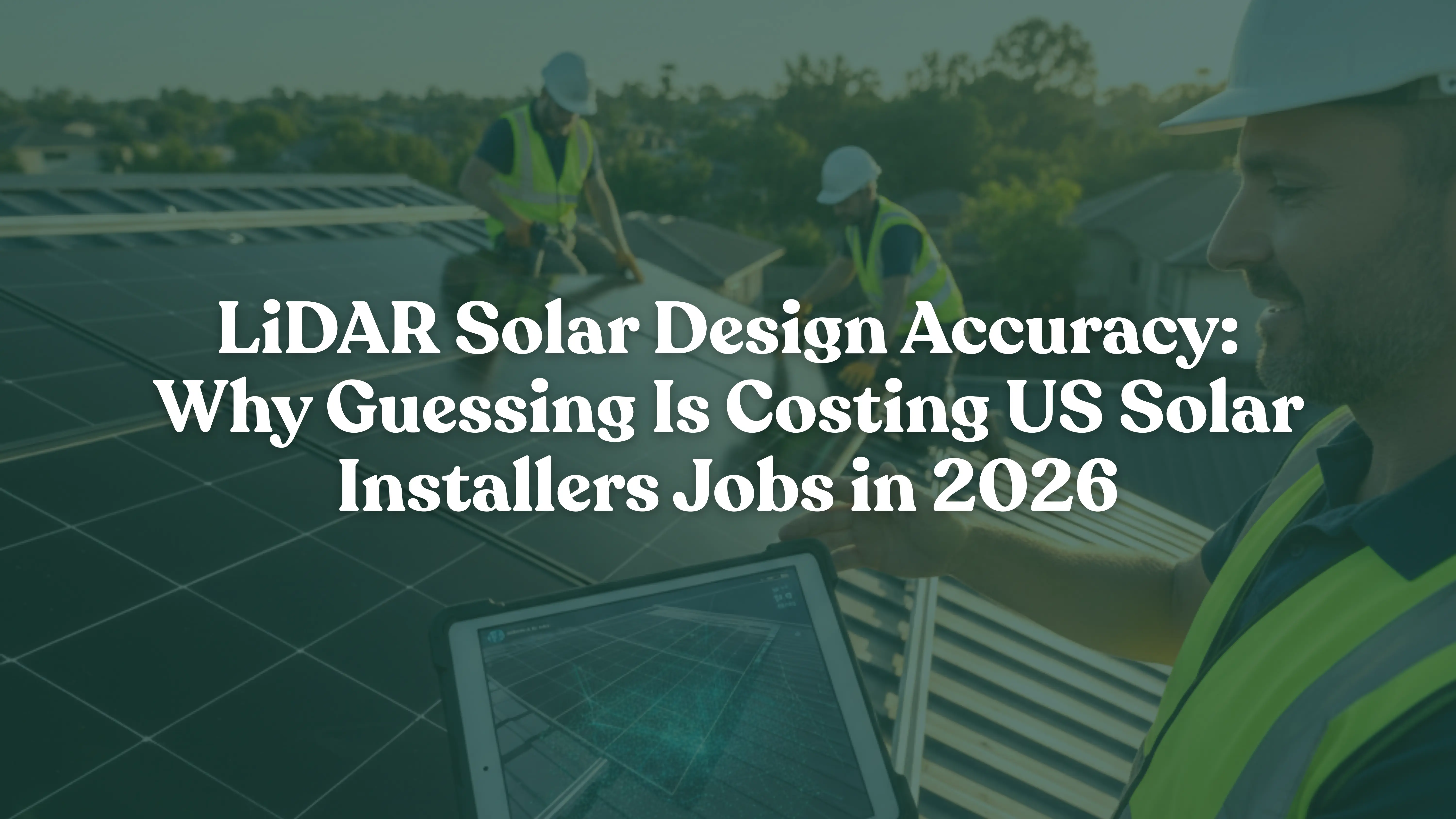
LiDAR Solar Design Accuracy: Why Guessing Is Costing US Solar Installers Jobs in 2026
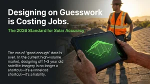
Introduction: The Cost of Designing on Guesswork
LiDAR solar design accuracy is quickly becoming the new standard for US solar installers — and for good reason. Most solar companies still design off satellite imagery that’s 1–3 years old, with elevation error margins of 30–100 centimeters. That gap between what the image shows and what’s actually on the roof is costing the industry real money every single day.
In 2026, design errors don’t just slow you down. They trigger permit revision cycles, push you back in utility interconnection queues, and give lenders a reason to reject your financing package. If you’re building your designs on inaccurate data, you’re building on sand.
This guide breaks down exactly what LiDAR accuracy changes for solar installers and EPCs — and how pairing a precision-first design workflow with certified engineering support from EnergyScape Renewables creates the bankable pipeline that today’s market demands.
Key Numbers at a Glance:
- Sub-5cm — LiDAR Horizontal Accuracy
- 20–35% — Permit Submissions Needing at Least One Revision Cycle
- $0.17/W — Soft Cost Savings from LiDAR-Based Site Assessment (NREL Estimate)
What Satellite Imagery Gets Wrong — And What It Costs You
Standard satellite imagery gives you a photograph. LiDAR gives you geometry. That difference matters enormously when your design needs to hold up to AHJ review, PE scrutiny, or lender underwriting.
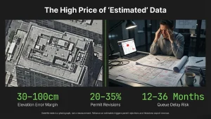
Satellite data carries elevation errors of 30–100cm, can’t reliably detect obstructions added in the past year, and doesn’t measure actual roof pitch — it estimates it. When your shading analysis is built on estimates, your production model is a guess dressed up as a number.
Industry data consistently shows that 20–35% of residential solar permit submissions require at least one revision cycle. Design inaccuracy drives a significant share of those rejections. Each revision cycle doesn’t just cost you time — it costs you your place in an interconnection queue that’s already stretching 12–36 months across major ISOs like CAISO, PJM, and MISO. Lose your queue position once, and you may wait another year to close that project.
Under NEM 3.0 and successor tariff structures emerging in California and other states, export rates matter more than ever. A design that overestimates production by even 8% — because your shading inputs were wrong — creates a real revenue gap for your customer. That’s not a customer service issue. That’s a chargeback conversation waiting to happen.
Key Stat: NREL estimates that LiDAR-based remote site assessment can reduce solar industry soft costs by $0.17 per watt. On a 10kW residential system, that’s $1,700 in soft cost savings per job. (Source: National Renewable Energy Laboratory)
LiDAR Solar Design Accuracy — What Changes at the Data Level
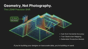
LiDAR — Light Detection and Ranging — fires laser pulses at a surface and measures the return signal to build a precise 3D point cloud. The result is a measurable, geometry-based model of the actual roof, not an approximation from an aerial photo.
LiDAR delivers sub-5cm horizontal accuracy and sub-10cm vertical accuracy. Compare that to the 30–100cm error range of standard satellite imagery. That accuracy difference directly translates into more reliable shading analysis, more accurate structural load calculations, and a production model that lenders and engineers can stand behind.
In 2026, tools like EagleView, Nearmap, and drone-based LiDAR providers have brought point cloud data to residential-scale projects at an affordable cost. This technology is no longer reserved for commercial and utility-scale work. It’s available now, and your competitors are starting to use it.
Bankability: How LiDAR-Accurate Designs Survive Financial Scrutiny
The solar financing landscape shifted significantly since 2021. With interest rates still elevated, lenders and tax equity investors are using bankability as a hard filter for residential and C&I solar projects. They’re requiring P50/P90 production estimates within tighter variance bands. A design built on inaccurate inputs produces wider P50/P90 spreads — which means more uncertainty — which means more friction in the financing process.
LiDAR-informed designs produce tighter spreads because the underlying data is more accurate. When your shading inputs reflect real obstruction heights and your roof geometry matches what’s actually there, your yield model becomes defensible. Financiers who review your package can see a production story that holds together.
More residential and commercial solar projects now move through TPO structures, securitization, and tax equity deals. In those workflows, the system must meet two sets of expectations — the installer’s and the financier’s. Recent analysis of TPO project submissions found that accurate, LiDAR-based site surveys significantly improved first-submission approval rates. First-pass approval reduces redesign costs, eliminates change orders, and keeps your install schedule intact.
What Bankability Means in 2026: Lenders don’t just want to see solar. They want a defensible production story — one that holds up under review, matches what’s actually on the roof, and was built by someone who knows the difference between 30cm accuracy and 5cm accuracy.
The Engineering Handoff — Why Clean Design Inputs Speed Up PE Stamping
PE-stamped structural and electrical drawings are required for most solar permit submissions. The speed at which those drawings get stamped depends almost entirely on the quality of the design that comes in.
EnergyScape Renewables (ESR) provides PE-stamped drawings, permitting packages, and solar engineering services for installers and EPCs across the United States. Their engineers review design inputs to build permit-ready documentation. When a design arrives with accurate geometry, real shading data, and measured roof pitch, the engineering review moves fast. When a design has gaps — incorrect pitch estimations, missing obstruction data, wrong panel placement — revision cycles slow everything down.
A LiDAR-accurate design gives ESR’s engineers clean inputs from day one. That means faster stamp turnaround, cleaner permit packages, and AHJ submissions that don’t come back with red lines. For installers running high-volume operations under IRA-driven demand, that speed is a direct competitive advantage.
The Sunscape Workflow: From LiDAR Design to Permitted Project
Sunscape is the solar CRM and project management platform built for installers who want to run cleaner, faster, more profitable projects. When Sunscape’s design environment works alongside LiDAR data, you get a connected workflow that looks like this:
- Design in Sunscape with LiDAR-quality inputs from day one
- Generate an accurate, engineering-review-ready design package
- Hand off to EnergyScape Renewables for PE-stamped drawings with zero revision cycles
- Submit a permit package that AHJs approve on first review
- Move through utility interconnection queues without losing your place
- Close financing with a bankable production model that survives underwriter scrutiny
This closed-loop pipeline — design in Sunscape, engineer with ESR, permit and fund — is what separates installers who scale cleanly from those who constantly absorb the cost of revision cycles. It’s not just a better workflow. It’s a business model that compounds over time.
2026 Market Factors Solar Installers Can’t Ignore
Several forces are converging right now that make LiDAR solar design accuracy more strategically important than ever before:
- IRA Install Volume: Higher project volume means less tolerance for per-job revision cycles. Accuracy at the design stage directly protects your margin per job.
- NEM 3.0 and Export Rate Sensitivity: In California and emerging in other states, production estimates carry real revenue consequences. Overestimate by 8%, and your customer feels it every month.
- Interconnection Queue Dynamics: Losing your queue position due to a design resubmission can mean a 12–24 month delay. That’s a project that didn’t get built this year.
- Financing Selectivity: Lenders require tighter P50/P90 spreads. LiDAR-backed designs deliver those spreads — satellite-based designs often can’t.
- AI + LiDAR Convergence: Design platforms now auto-generate roof segments, tilt angles, and obstruction buffers from point cloud data. This technology is mainstream in 2026, not experimental.
For more industry context, the SEIA U.S. Solar Market Insight report and NREL’s soft cost research provide current data on permit timelines, interconnection trends, and cost reduction pathways.
Conclusion: Accuracy Is Now a Business Requirement
In 2026, LiDAR solar design accuracy is not a premium feature. It’s a business requirement. The market — financiers, AHJs, utilities, and your own margins — is making that clear.
Installers who design with accurate, LiDAR-quality data, engineer with certified partners like EnergyScape Renewables, and manage their pipeline through a platform like Sunscape are building a bankable, scalable operation. Those who rely on outdated satellite imagery and hope for the best are absorbing unnecessary costs that compound with every job.
The difference between a permit that clears on the first submission and one that cycles twice isn’t luck. It’s data quality from the very first design decision.
Ready to Build Bankable Solar Projects?
🔆 Sunscape Solar — Design Built for Engineering Review from Day One
Most solar installers are designing projects that look finished but aren’t engineering-ready. Sunscape changes that. Built specifically for US solar installers and EPCs, Sunscape’s CRM and project management platform helps you manage every job from first site capture to final permit submission — with workflows designed to produce clean, accurate, review-ready design packages that move fast through engineering and AHJ review. Stop absorbing the cost of revision cycles. Start building projects that hold up the first time.
⚡ EnergyScape Renewables — PE-Stamped Packages That Move Through AHJ Review
Pair your LiDAR-accurate design with certified engineering credentials. EnergyScape Renewables delivers PE-stamped structural and electrical drawings, permitting packages, and solar engineering services for installers and EPCs across the United States. When your upstream design is clean and accurate, ESR’s engineering team can stamp, package, and submit without revision cycles — keeping your interconnection queue position intact and your project timeline on track. Clean design inputs. Fast engineering turnaround. Permit packages that AHJs approve the first time.
FAQ: LiDAR Solar Design Accuracy for US Solar Installers
Q: What is LiDAR solar design accuracy?
LiDAR solar design accuracy refers to using Light Detection and Ranging laser scanning data to create precise 3D models of rooftops for solar panel placement. LiDAR achieves sub-5cm horizontal accuracy, compared to 30–100cm error margins in standard satellite imagery. This precision improves shading analysis, structural load calculations, and production estimates — resulting in more bankable solar designs.
Q: How does LiDAR improve solar permit approval rates?
LiDAR-based designs provide accurate roof geometry, real obstruction mapping, and measured tilt angles. When these inputs are correct, engineering review moves faster and permit packages are cleaner. Industry data suggests 20–35% of residential solar permits require at least one revision cycle — and design inaccuracy is a leading cause. Accurate LiDAR data significantly reduces those revision cycles.
Q: Why does solar design accuracy matter for project financing?
Lenders and tax equity investors require tight P50/P90 production estimate spreads before approving solar project financing. A design built on inaccurate satellite data produces wider uncertainty ranges. LiDAR-backed designs produce tighter, more defensible production models — which means faster financing approval and fewer obstacles in TPO and securitization workflows.
Q: What is a bankable solar design?
A bankable solar design is one that meets the accuracy, documentation, and engineering standards required by lenders, utilities, and AHJs. It includes accurate production estimates, PE-stamped structural and electrical drawings, and a shading analysis grounded in measured data. LiDAR-based designs are considered more bankable because they reduce the risk of production overestimation and design-related permit rejections.
Q: How does EnergyScape Renewables use LiDAR design data?
EnergyScape Renewables provides PE-stamped solar engineering services for installers and EPCs across the US. When a design is based on accurate LiDAR data, ESR’s engineers can review, stamp, and package permits faster — with fewer revision cycles. Clean design inputs directly reduce the time between design submission and permit approval.
Q: What is the cost saving from LiDAR-based solar site assessment?
NREL estimates that LiDAR-based remote site assessment can reduce solar soft costs by $0.17 per watt. On a typical 10kW residential system, that translates to approximately $1,700 in soft cost savings per job. Across a high-volume installer’s annual project pipeline, the cumulative savings are substantial.
sjayakanth@energyscaperenewables.com