
Solar Site Survey Technology 2026: Apps, Drones & Mobile Tools Compared

Solar Site Survey Technology 2026 Transforms How US Installers Operate
Running a solar installation company means managing thousands of details. You track leads, schedule crews, design systems, and handle permits. However, none of that matters if your site survey strategy isn’t locked down. The problem hits hard: inaccurate surveys waste time and money. Your crew rolls out for two hours, misses critical data, and consequently you chase revisions for weeks. As a result, customers get frustrated and your margins shrink.
The solution? Modern approaches have finally closed this gap. In 2026, site surveys aren’t limited to tape measures and clipboards anymore. Today’s installers use drones, AI-powered apps, LiDAR imaging, and mobile tools that deliver accuracy at scale. Therefore, we’ll walk you through the best options available—so you can pick what works for your operation.
Drones: The Game-Changer in Solar Site Survey Technology

Drones represent the biggest shift in data collection for 2026. Notably, this isn’t because they’re new, but because they’ve become practical and affordable for most operations.
A professional drone survey captures hundreds of data points in minutes. Your crew flies the property once, and subsequently the flight plan runs automatically. Software stitches photographs into orthomosaics—ultra-detailed aerial maps of your entire site. Additionally, thermal imaging reveals electrical issues before they become problems. A DJI Matrice 350 RTK with LiDAR payload completes the same survey in 28 minutes, produces a 3D point cloud accurate to 1.5 centimeters, and the pilot never sets foot on the roof. In contrast, traditional surveys require a full day for that same accuracy.
Drones capture hundreds of data points to model how trees and nearby buildings impact sunlight throughout the year. This data is then processed by solar shading analysis software for high-precision production estimates. Popular platforms include the DJI Matrice 350 RTK for commercial projects and DJI Mavic 3 Enterprise for residential work. Furthermore, software like Scanifly integrates drone captures directly into solar design, cutting revision rates dramatically.
Mobile Apps and Remote Assessment Solutions

Not every job needs a drone. Alternatively, sometimes you need speed. That’s where mobile solutions come in.
Modern mobile survey tools let customers submit data without a site visit. They upload roof photos, electrical panel images, and utility information through a simple app. Subsequently, your design team pulls satellite imagery and cross-references utility records. In hours, you’ve got enough data for preliminary assessment. Digital shading tools help you measure solar access and document roof conditions during site surveys. Solmetric SunEye is designed specifically for shade analysis.
These platforms work because remote assessment accuracy has improved significantly. A modern workflow stacks four data layers: high-resolution aerial and LiDAR imagery for roof planes, pitch, azimuth, and obstructions. You dispatch crews only when it matters. If remote analysis flags a tile roof or unknown electrical service, you send a tech. Otherwise, design proceeds remotely. Notably, this approach cuts truck rolls by forty to fifty percent at mature companies. As a result, you achieve lower acquisition costs and faster proposal turnarounds.
Solar Site Survey Technology Integration With Design Platforms
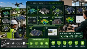
The best tools aren’t standalone. Rather, they integrate directly with your design platform. Arka 360 includes a native Solar CRM with integrated design, lead management, and task tracking. AI-Powered Automation includes a high-speed layout tool that handles complex roof geometries with near-perfect accuracy. Additionally, this eliminates data handoffs between platforms.
Platforms like Aurora Solar, Solargraf, and Enact Solar accept drone-derived 3D models as base data. Consequently, your point cloud becomes the foundation for system design. Furthermore, software automatically identifies obstructions, calculates shading loss, and suggests optimal placement. Scanifly replaces manual surveys and satellite imagery with drone-based 3D reconstructions. A drone flight captures roof geometry with 1-3 inch accuracy. Clearly, this precision directly impacts design quality and reduces revision cycles. Moreover, the integration streamlines your entire workflow from capture to proposal.
Selecting the Right Tool for Your Operation
You don’t need every tool. Rather, you need the right combination for your workflow. For residential installers: start with a mobile app (SiteCapture, QuoteIQ) plus satellite imagery. Additionally, add drone capability when volume hits fifty-plus projects monthly. Remote assessments handle most work, and dispatch crews for complex situations.
For commercial EPCs: drones are non-negotiable. Furthermore, invest in LiDAR capability for multi-level roofs. Integrate drone data with enterprise design platforms. Your clients expect precise proposals backed by professional documentation. Significantly, this comprehensive approach builds credibility with commercial customers.
For mixed portfolios: build a hybrid approach. Use remote methods for screening. Additionally, deploy drones for complex projects. This balanced strategy maximizes efficiency across different project types. The mistake most installers make? Assuming one method beats all others. In reality, best-performing companies triage—they route jobs by complexity, not by default. Ultimately, this strategic routing improves profitability significantly.
Measuring Your Return on Investment

Modern survey equipment costs money. Specifically, drones run eight to fifteen thousand dollars and software subscriptions add two to five hundred monthly. Is it worth it? Yes. However, not for the reason you think.
The real return isn’t in survey cost. Rather, it’s in revision rate. A remote assessment that misses service upgrade information triggers a truck roll costing twelve hundred dollars plus delayed installation. Therefore, track your revision rates by method. If remote jobs generate revisions above eight percent, your capture standards need improvement.
Mature companies using advanced approaches report fifteen to twenty percent faster cycle times. Moreover, sales teams close more deals because proposals land within forty-eight hours. Additionally, field crews work from accurate data, cutting rework significantly. The math works: a single avoided revision pays for months of software subscription. Indeed, most installers recover their investment within the first quarter.
Getting Started With Modern Solar Site Survey Technology Methods
The tools available today have become table stakes in 2026. Clearly, you either adopt them or watch competitors close faster deals. The problem isn’t technology—it’s implementation. Which solutions fit your operation? Furthermore, how do you integrate them without multiple software subscriptions?
That’s where Energyscape Renewables steps in. We support solar installers and EPCs across all fifty states with back-office infrastructure for advanced workflows. From remote assessment triage frameworks to drone data processing, we help you implement modern methods efficiently.
Once surveys are locked in, you need a CRM built for solar. Therefore, Sunscape Solar provides the platform where survey data feeds directly into your design-to-installation workflow. Manage leads, track projects, coordinate crews, and monitor performance—all built for how solar companies work. Modern approaches aren’t just about better data. Rather, they’re about faster decisions and sustainable competitive advantage. The companies that move first typically dominate their markets within eighteen months.
sjayakanth@energyscaperenewables.com